WASHINGTON, Jan 9 (NNN-AGENCIES) — A massive winter storm system has unleashed dangerous blizzard conditions in parts of the central United States, shutting down highways and stranding drivers in frigid temperatures Monday, and it’s pummeling parts of the South with hail storms, heavy flooding and tornado threats.
The fast-moving storm is making its way east and will cover over 1,800 miles in 72 hours, producing notable snowfall across more than half a dozen states.
The system strengthened as it tracked out of the Four Corners region – where it dumped snow that brought some travel to a halt Sunday – and into the southern Plains Monday afternoon.
By Monday evening, heavy snow and powerful winds stretched from the Texas Panhandle to Nebraska, where authorities had already responded to dozens of weather related-incidents on the road and urged residents not to travel because of the dangerous whiteout conditions.
In Kansas, one highway patrol trooper warned the blizzard conditions and blowing snow were making it so difficult to see that authorities were having difficulty with rescues.
“Please stay home,” the trooper said on social media. “We will not be able to rescue you if you get stuck because we are having trouble getting around.”
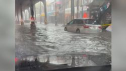
Further south, heavy showers and hailstorms were moving through Mississippi and parts of Louisiana, while millions of people were also at risk of tornadoes.
The first tornado watch of 2024 was issued Monday for parts of Texas and southwest Louisiana. A second tornado watch was issued through Monday night for southeast Louisiana and coastal Mississippi and covers cities including Baton Rouge and New Orleans.
All that comes as more states prepare for severe weather Tuesday, including parts of the Northeast, where leaders have warned of potentially dangerous rain and coastal flooding.
More than 9 million people were under a Level 3 out of 5 severe storm threat Monday from Texas to Florida. More than 11 million people face the same threat level Tuesday from the Panhandle of Florida to the Outer Banks of North Carolina.
The tornado risk will increase Monday night – an incredibly dangerous situation for parts of the Gulf Coast. Tornadoes at night are twice as deadly as those that occur during the day, mainly because a large portion of the population is asleep and miss warnings.
Meteorologists at the National Weather Service office in Mobile, Alabama, warned of “an extremely high impact event for our area” that “could be one of the more impactful non-tropical systems” to hit their forecast area.
The same system is forecast to move across the Southeast throughout Tuesday. There is a Level 3 out of 5 risk of severe storms for Tallahassee, Florida, Savannah, Georgia, Charleston, South Carolina, and Jacksonville, Florida. Tornadoes and damaging winds are also threats with the strongest storms.
New York City issued a travel advisory and flood watch that’s set to start Tuesday evening, warning of heavy rain, strong wind and the potential of coastal flooding.
“Let me be clear,” New York Gov. Kathy Hochul said in a Monday news briefing. “This will be an emergency, it will be serious and we’re urging all New Yorkers to exercise extreme caution at this time.”
More than 100 million people across the US are under wind alerts that span Monday, Tuesday or both days.
Coastal areas are likely to endure some of the strongest winds from the storm.
Winter storm alerts stretch over 1,000 miles from Arizona to Michigan as the storm carves its path. — NNN-AGENCIES